
Historypin has set itself the rather modest target of becoming the,
"world's largest archive of historical images and stories."
Despite the fact that there are a few websites out there already mapping historical photographs I think Historypin has two things going for it which should help it achieve its aim.
Firstly, and most importantly, Historypin has the backing of Google. The site is a joint effort between the search giant and We Are What We Do. Google's support means that Historypin will have a global reach and access to Google's technology and talent.
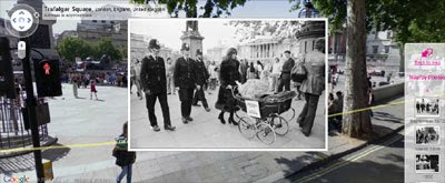
Secondly, Historypin has a killer unique selling point in its overlaying of photographs on top of Street View. Superimposing the historical view on top of the present scene in Street View really gives the user a unique window into the past.

Historypin is already populated with historical photographs from contributors as diverse as the Royal Albert Hall and UK shopping chain Marks and Spencer. However it will survive or die on its success in getting the public to upload the old photogrpahs in their own family collections.
It will be helped in this task by the great interface it has developed for adding a photograph to the map and superimposing it on Street View. I've spent a lot of time myself trying to line-up historical photographs with Street View and I wish I'd had Historypin's tools to help me. They really do make the process very easy.
Another incentive to the public to upload their photos will be Historypin's linking of photographs with stories. When users upload photographs to the site they are invited to tell the stories behind the pictures. This makes browsing the uploaded photographs a fascinating experience. It should also encourage individuals to upload their photography albums, as they can tell the story of their immediate ancestors and share their family histories in a truly unique and visually interesting manner.

In the future Historypin plans to add other layers to its historical mapping interface, such as sound and video. I've seen a demo in which Historypin overlays video on Street View, which is truly amazing.
This is another area where the partnership with Google should prove invaluable. Having access to the archival video footage already available on YouTube should give Historypin an immediate head-start over other video mapping sites.
Also See
- SepiaTown - geo-tags historical photographs on Google Maps
- History View - comparison of historical photos & Street View
- Then & Now - Australian Google Map showing historical photos alongside Street View images
- LookBackMaps - collection of historical photographs compared to Street View
- Utrecht van Boven - historical photos of Utrecht on a Google Map
- Sydney Sidetracks - a map of audio, video and photographic records of Sydney's past
- HistoGrafica - historical photographs on Google Maps
- Oldmos - historical photos of Moscow
2 comments:
This is great - I can't wait to check out the site. FYI, the historypin link at the top of the article needs a www after the http://
Also, it's We Are What We Do not We Are We We Do though I kind of like the sound of the incorrect one.
We Are We! We Do! ;)
Thanks ....edited.
been kind of a long day)
Post a Comment